-
Language

To build your own Itinerary, click  to add an item to your Itinerary basket.
Already saved an Itinerary?

To build your own Itinerary, click to add an item to your Itinerary basket.
Already saved an Itinerary?


| Open Christmas |
|---|
| Open New Year |
|---|
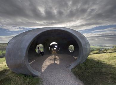
| Halo - Panopticon (1 Jan 2024 - 31 Dec 2024) |
|---|
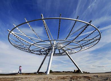
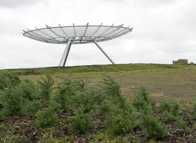
Halo: Landranger 103 Blackburn, Burnley and surrounding area, 1:50 000 scale. Grid ref 795238
From M65: Exit junction 8 and take A56/A6068 exit to Bury/Manchester/M66/Clitheroe. At the roundabout take the exit onto A56 heading to Manchester/Bury/M66/Accrington/A679. At the roundabout take the 1st exit onto Blackburn Road/A680 heading to Haslingden. After approx 1/2 mile and immediately after some traffic lights, turn left steeply up Hud Rake, which becomes High Street. 400 yards further on, there is a sharp left turn on to Higher Lane. Only residents and those with disabled parking permits have vehicle access beyond this point, so park in the town and walk up Higher Lane towards 'Halo' (approx 10 minutes).
From M66: Continue on A56 and take the A680 exit towards Haslingden. At the roundabout take the exit onto Manchester Road/A680, and at the next roundabout take the exit onto Haslingden Road/A681. Turn left at Union road, and then left at Haslingden Old road, continue onto Kirk Hill Road. Turn right at Laund lane and take the 1st left towards Cribden End Lane. 400 yards further on, there is a sharp left turn on to Higher Lane. Only residents and those with disabled parking permits have vehicle access beyond this point, so park in the town and walk up Higher Lane towards 'Halo' (approx 10 minutes).
For public transport information out of normal office hours contact:
Travel Line: 0871 200 2233 (for bus services around the Lancashire area)
National Rail Enquiries 08457 48 49 50
Haslingden Market is not trading regularly at present due to undergoing renovation works.…
Set in the picturesque valley, it is the premier outdoor ski and snowboarding centre in…
Whitaker Park is a large park on the outskirts of Rawtenstall. The facilities available…
Set in the beautiful Whitaker Park in Rawtenstall, it’s a great day out for all. A…
If you’re looking for exciting skate action with a rocking music mix and vivid party…
Charge through the custom-built District A Laser Tag Arena at Adrenaline, unearthing…
Challenge yourself and conquer new heights at the state-of-the-art indoor climbing…
You will find fresh produce, butchers, fishmongers, traditional deli, Italian deli, fresh…
In the old St Stephens Church, surrounded by beautiful countryside, are over 30 antique…
Recently renovated meadowland course, offering a real test and plenty of variety; from…
Visit a place where Lancashire’s industrial past is brought to life through a…
Marl Pits Leisure Centre is home to a main swimming pool, smaller teaching pool, a gym…
Step into The Squirrel’s Lair. A new 18 hole, woodland themed adventure golf course set…
If you are serious about golf, or a family looking for a great day out, there's something…
A traditional West Pennine working hill farm with 16 hectares of land above Helmshore.…
Take a visit to Clough Head Visitor Centre to find out more about the local landscape,…
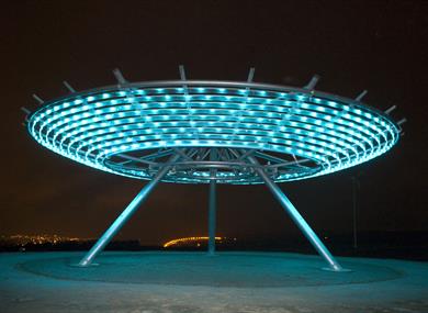
 Colourfields - Panopticon, BlackburnBlackburn's Panopticon, Colourfields, is a dramatic transformation of the former cannon battery in Blackburn's Corporation Park.
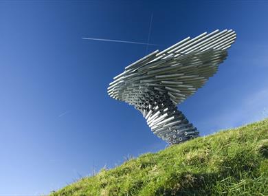
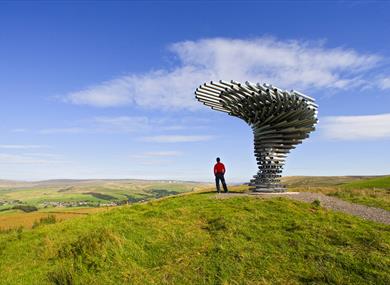 Singing Ringing Tree - Panopticon, BurnleyBurnley's Panopticon, 'Singing Ringing Tree', is a unique musical sculpture which overlooks Burnley from its position high above the town on Crown Point.
 Atom - Panopticon, WycollerPendle's Panopticon, 'Atom', rests on the hillside above Wycoller village in Wycoller Country Park.
 Haslingden, Haslingden
 Panopticons, LancashirePanopticons is the name of a unique series of 21st-century landmarks being erected across East Lancashire, from Blackburn to Pendle, with funding from the Northwest Regional Development Agency and the Lancashire Economic Partnership.
© Visit Lancashire 2024. The Official Website of Marketing Lancashire. All Rights Reserved