


In Latest News
To build your own Itinerary, click  to add an item to your Itinerary basket.
Already saved an Itinerary?


Six of Blackpool's Top Attractions, One Ultimate Ticket
Do more, see more and save more with the new Ultimate Ticket from Blackpool Tourism Limited.
Visit all of Blackpool's leading attractions for just £65 and enjoy the best of what Blackpool has to offer.
The Ultimate Ticket grants you entry to 6 of Blackpool's top attractions, including:

Purchase a season ticket for the gardens for £12.50 - and after 5 visits you will get a free Exchange Coffee Coffee from our Cart Shed Tearoom!
We are dog friendly, and there are numerous walks for you to enjoy. Including one through the forestry and around our 3-acre lake.
Valid for one year form purchase, and access to the gardens is only on public open days alongside the tearoom.
Offer code SEASONTICKET

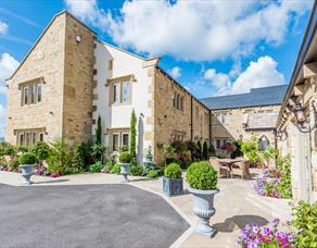
THE INDULGENCE ESCAPE
The Ultimate Foodie Retreat
Escape to a stay designed purely for pleasure. The Indulgence Escape is your invitation to switch off, slow down and savour every moment.
From the second you check in, indulgence begins. A bottle of perfectly chilled sparkling wine awaits in your room, paired with artisan chocolates – the perfect welcome to your gourmet getaway.
Spend your afternoon your way. Wander through peaceful woodland walks, breathe in the fresh country air, or simply settle in and relax in luxurious comfort. This is time that’s entirely yours.
As evening falls, the experience truly comes to life. Take your seat in one of our two AA Rosette-awarded restaurants and enjoy £50 per person to spend on our à la carte menu. Expect beautifully crafted dishes, exceptional ingredients, and a dining experience that celebrates flavour at its finest.
After a restful night’s sleep, awaken refreshed and ready for one final treat – our generous breakfast feast. Tuck into a full English breakfast with all the trimmings, alongside yoghurts, fresh fruit, preserves, and an irresistible selection of pastries.
We haven’t called it The Indulgence Escape for nothing.
This is more than a stay – it’s a celebration of great food, fine wine and well-deserved relaxation.
Valid for stays Sunday to Friday from 1st April until 31st August 2026
Just £250
for two people
Special Offer Terms and Conditions apply. Prices are based on two people sharing a bedroom. Valid Sundays – Fridays from 1st April 2026 until 31st August 2026, subject to availability. Full payment is required upon purchase, which is non-refundable. Should you need to request a date change, please contact us at your earliest convenience to check our availability; however, we cannot guarantee that this will be possible based on the demand for this Special Offer. Offer will be withdrawn without prior warning if sold out. Upgrades available. The Woodland Spa is not included in this offer – contact them separately in you wish to add on a visit to the Thermal EXperience.
20% Off Advanced Purchase Rate
When you book 14 days in advance.
Available Sunday - Thursday.
Book your stay in advance and you are guaranteed to get the best room rate possible.
Non-refundable rate payment will be taken on confirmation of booking.
Room only and bed and breakfast rates.
Terms and conditions apply.

15% off at Go Ape Blackburn
Book online, using promotional code: VLANCA26.
Valid until Thursday 31st December 2026.
Offer cannot be used in conjunction with any other offer. Excludes Saturdays.
Applicable on all activities at Go Ape Blackburn and Go Ape Rivington only.
Booking terms and conditions apply.

15% off at Go Ape Rivington
Book online, using promotional code: VLANCA26.
Valid until Thursday 31st December 2026.
Offer cannot be used in conjunction with any other offer. Excludes Saturdays.
Applicable on all activities at Go Ape Blackburn and Go Ape Rivington only.
Booking terms and conditions apply.

Save 20% off your first quest.
Looking for something a little different to do in Lancaster?
Step away from the usual sightseeing and dive into an interactive treasure hunting experience that turns the whole city centre into your adventure playground.
Offer code:PLAYLANCASTER
Terms and conditions apply.

DEAREST GENTLE READERS – I promised you the Wedding Package of the season for all those who have found the magic of a love match – here it is – limited dates January to March & October to December 2027
“ The Wedding of the Season” PACKAGE
This new later start package in our selection has been created in
response to discussion with today’s couples.

|
Winter Wedding Package at Holland Hall Winter Wedding Package - Special Offer Say “I Do” in a Season of Sparkle £3,495* based on 50 guests Special offer for all new bookings on remaining dates from October 2026 until February 2027 *Please note: a supplement will apply for weekend dates We would like to offer you the opportunity to celebrate your wedding & reception with us at a specially reduced cost, starting from £3,495*. The price includes everything you need for 50 guests attending the entire wedding day, available from 2pm. —————————— WHAT’S INCLUDED IN OUR WINTER WEDDING PACKAGE BRIDAL LOUNGE | for all prep, hair & make up THE LOUNGE | pre-ceremony prep area for you and your party GARDEN & TERRACE ROOM HIRE | including chosen ceremony area if required ACCESS TO PRIVATE GARDEN AREA BOSE SPEAKER & MUSIC COORDINATION | for ceremony CHIAVARI CHAIRS & SASHES | to compliment your chosen scheme BEER & BUBBLY ARRIVAL DRINKS WHITE TABLE LINEN EVENING HOT & COLD BUFFET | 6 options OVERNIGHT STAY | including breakfast DEDICATED WEDDING MANAGER —————————— Enhance Your Day with Optional Upgrades – Additional Cost Multi Award Winning Venue – Hotel Wedding Venue of the Year T&C's apply - £3,495* based on 50 guests Special offer for all new bookings on remaining dates from October 2026 until February 2027 |

Say I do in the golden hour with our Sunset Package available Saturday 27th June, 4th July, 25th July, 1st August (sold out), 8th August and 15th August 2026 for only £5600.00.
Offer includes:
Civil ceremony room hire from 4pm
Flower arrangement for your ceremony table
Chair covers with your choice of coloured sash
Glass of fizz on arrival
Cocktail Sandwiches
Hire of the Great for your evening reception
Blossom trees for your photographs
BBQ or Manor Buffet
Hire of cake stand and knife
DJ
Overnight accommodation for the happy couple
For 100 guests only, should you wish to add further guests, they must attend the whole event and you will be charged per person.
Available on Fridays and the above Saturdays for new bookings only.
Price inclusive of VAT.
Available on Fridays and the above Saturdays in 2026 only
New Bookings only

Lancaster Arts
Save up to 20% on full price tickets with the concert season ticket offer.
Save 10% when you book two concerts at the same time, 15% when you book three, and 20% when you book all four.
Simply add the tickets to your basket and the discount will automatically be applied.
Please note: the discount is only applied to full price tickets so excludes Lancaster Arts Supporter tickets and student/Under26 tickets.
Terms and conditions appy.

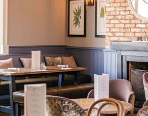
Midweek lunches, thoughtfully prepared. Our Set Lunch menu celebrates simple pleasures and seasonal ingredients, cooked with care and served without rush. Enjoy two courses for £20 or three for £25, Wednesday to Friday from 12pm–5pm.
Ideal for relaxed lunches, catch-ups and midweek treats. Available to book online or for walk-ins.
Enjoy two courses for £20 or three for £25, Wednesday to Friday from 12pm–5pm. Available to book online or for walk-ins.

Six of Blackpool's Top Attractions, One Ultimate Ticket
Do more, see more and save more with the new Ultimate Ticket from Blackpool Tourism Limited.
Visit all of Blackpool's leading attractions for just £65 and enjoy the best of what Blackpool has to offer.
The Ultimate Ticket grants you entry to 6 of Blackpool's top attractions, including:

Your date with love starts here.
Bespoke £3,000 wedding package crafted with love, and you in mind.
Available on all remaining 2026 dates.
inclusive of 30-day guests and 60 evening guests.
What's included? Bridal makeup room on the morning of the wedding; exclusive hire of the wedding suite for your special day; civil ceremony room hire; master of ceremonies;
contemporary centrepieces, glass of your chosen drink for the drinks reception, one glass of wine per guest with the meal; glass of fizz for the toast; three-course wedding breakfast from the set menu; evening food; use of cake stand and cutting knife; white linen tablecloths and napkins; chiavari chairs with a sash; master suite for the wedding night, use of landscaped gardens for photography; private licensed bar until 00:30.
Terms and conditions apply.

Six of Blackpool's Top Attractions, One Ultimate Ticket
Do more, see more and save more with the new Ultimate Ticket from Blackpool Tourism Limited.
Visit all of Blackpool's leading attractions for just £65 and enjoy the best of what Blackpool has to offer.
The Ultimate Ticket grants you entry to 6 of Blackpool's top attractions, including:

Get 20% off a midweek stay in a luxury Bell Tent.
Ribble Valley Retreat offers a stunning setting on a working farm, surrounded by incredible views.
Bell Tents are furnished with style and equipped with everything you need for a relaxing stay in this beautiful part of Lancashire.
With Langho rail station opposite it's a convenient base to explore the quirky cafes, independent bars and restaurants of Whalley and Clitheroe.
Surrounded by historical places of interest, boutique shops and walking and trails, this is the perfect location to explore the Ribble Valley.
Or simply relax, toast marshmallows, and let the scenery do the talking.
Unfortunately no dogs
Offer is only valid on 2 night stays or more
Occupancy up to 2 adults and 2 children
Offer code LANCS20

Six of Blackpool's Top Attractions, One Ultimate Ticket
Do more, see more and save more with the new Ultimate Ticket from Blackpool Tourism Limited.
Visit all of Blackpool's leading attractions for just £65 and enjoy the best of what Blackpool has to offer.
The Ultimate Ticket grants you entry to 6 of Blackpool's top attractions, including:
Dining offers
Two courses for £22.00.
Three courses for £26.00.
Available Monday - Friday every week.
Terms and conditions apply.

Six of Blackpool's Top Attractions, One Ultimate Ticket
Do more, see more and save more with the new Ultimate Ticket from Blackpool Tourism Limited.
Visit all of Blackpool's leading attractions for just £65 and enjoy the best of what Blackpool has to offer.
The Ultimate Ticket grants you entry to 6 of Blackpool's top attractions, including:

Buy One Ticket Get One Half Price!
Buy one get one half price.
Quote MOTHERSDAY18 when booking.
Applicable to all shows excluding previews.
Ratings
Powered By
![]()
© Visit Lancashire 2026. The Official Website of Marketing Lancashire. All Rights Reserved